category-icon

Via Regia Niemcy

463 km
3016 m
2971 m
no photo

Charakterystyka trasy

2022-07-27
category-icon
463 km
3016 m
2971 m
1.0/6

Komentarze

NA TYCH TRASACH PRZYDA CI SIĘ MAPOPRZEWODNIK LUB MAPA Z NASZEJ APLIKACJI

Zittau Mountains
MAPA TURYSTYCZNA W APLIKACJI TRASEO
Zittau Mountains

The Zittau Mountains, formerly also called the Lusatian Ridge, refer to the German part of the Lusatian Mountains that straddle the Saxon-Bohemian border in the extreme southeast of the German state of Saxony. Cycling and walking trails are marked on the map.

Saksońska Szwajcaria - część zachodnia
MAPA TURYSTYCZNA W APLIKACJI TRASEO
Saksońska Szwajcaria - część zachodnia

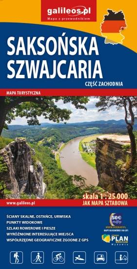
Mapa obejmuje zachodnią część Saksońskiej Szwajcarii w Niemczech. Na mapie zaznaczono kurorty i miasteczka oraz atrakcje turystyczne regionu niemieckich Gór Połabskich, ponadto jest tu: Bastei, Twierdza Königstein, Hohnstein z zamkiem, formy skalne Schrammsteine. Zawiera szlaki piesze i rowerowe oraz wszystkie informacje potrzebne turyście. Mapa opisana na siatce WGS 84, zgodna z polskimi systemami nawigacyjnymi.

Szwajcaria Saksońska część wschodnia
MAPA TURYSTYCZNA W APLIKACJI TRASEO
Szwajcaria Saksońska część wschodnia

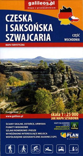
Mapa obejmuje pogranicze Czeskiej i Saksońskiej Szwajcarii. Zaznaczono na niej wszystkie formy skalne regionu, kurorty i miasteczka oraz atrakcje przy nich, czyli: Sebnitz, Mikulášovice, Hinterhermsdorf, Jetřichovice, Růžová oraz Kuhnstal, Pravčicka brana, Idaggrottę, Affelsteione, spływy łodziami i inne. Na mapie oznaczono szlaki piesze i rowerowe oraz wszystkie informacje potrzebne turyście. Mapa opisana na siatce WGS 84, zgodna z polskimi systemami nawigacyjnymi. Rok wydania 2023

Lusatian Mountains
MAPA TURYSTYCZNA W APLIKACJI TRASEO
Lusatian Mountains
The Lusatian Mountains are a mountain range of the Western Sudetes on the southeastern border of Germany with the Czech Republic. They are a continuation of the Ore Mountains range west of the Elbe valley. The mountains of the northern, German, part are called the Zittau Mountains. The range is among the westernmost extensions of the Sudetes, which stretch along the border between the historic region of Silesia in the north, and Bohemia and Moravia in the south up to the Moravian Gate in the east, where they join the Carpathian Mountains. The northwestern foothills of the Lusatian Mountains are called the Lusatian Highlands; in the southwest the range borders on the České Středohoří mountains. Both the German (Zittau Mountain Nature Park) and the Czech (Lusatian Mountain Nature Park or ChKO Lužické hory) parts nowadays are protected areas.
Bohemian Switzerland, Šluknov Region
MAPA TURYSTYCZNA W APLIKACJI TRASEO
Bohemian Switzerland, Šluknov Region
Bohemian Switzerland (Czech: České Švýcarsko), also known as Czech Switzerland, is a picturesque region in the north-western Czech Republic. It lies on the Czech side of the Elbe Sandstone Mountains north of Děčín on both sides of the Elbe River. It extends eastward into the Lusatian Mountains and westward into the Ore Mountains. Its highest elevation is the mountain Děčínský Sněžník at 726 m above sea level. It has been a protected area (as ChKO Labske Piskovce) since 1972. The National Park is adjacent to the Saxon Switzerland National Park (Sächsische Schweiz) in Germany.
Jizera Mountains
MAPA TURYSTYCZNA W APLIKACJI TRASEO
Jizera Mountains
Jizera Mountains or Izera Mountains are part of the Western Sudetes on the border between the Czech Republic and Poland. The range got its name from the Jizera River, which rises at the southern base of the Smrk massif. The range stretches from the Lusatian Mountains (Zittau Mountains) in the northwest to the Krkonoše in the southeast. The highest peak is Wysoka Kopa (1,127 m) near the town of Szklarska Poręba in Poland. Neverteheless, a better-known mountain is Smrk (1124 m), with a recently rebuilt look-out tower. The Jizera Mountains are an attractive location for winter sports, cycling and hiking. The centre for both downhill skiing and ski run is Bedřichov.