category-icon

Tour of Burgundy - official route

656 km
0 m
Oficjalny przebieg
Polecamy

Route characteristics

2025-04-27
category-icon
656 km
0 m
0 m
6/6

Tour of Burgundy route map


The Tour of Burgundy bike trail is a scenic route of about 656 kilometers, forming a loop through the heart of Burgundy. It leads through historic towns, castles, world-renowned vineyards and tranquil canals, making it an ideal choice for lovers of wine, history and active recreation.

Attractions along the route


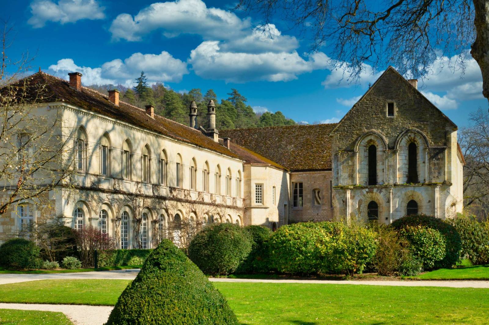
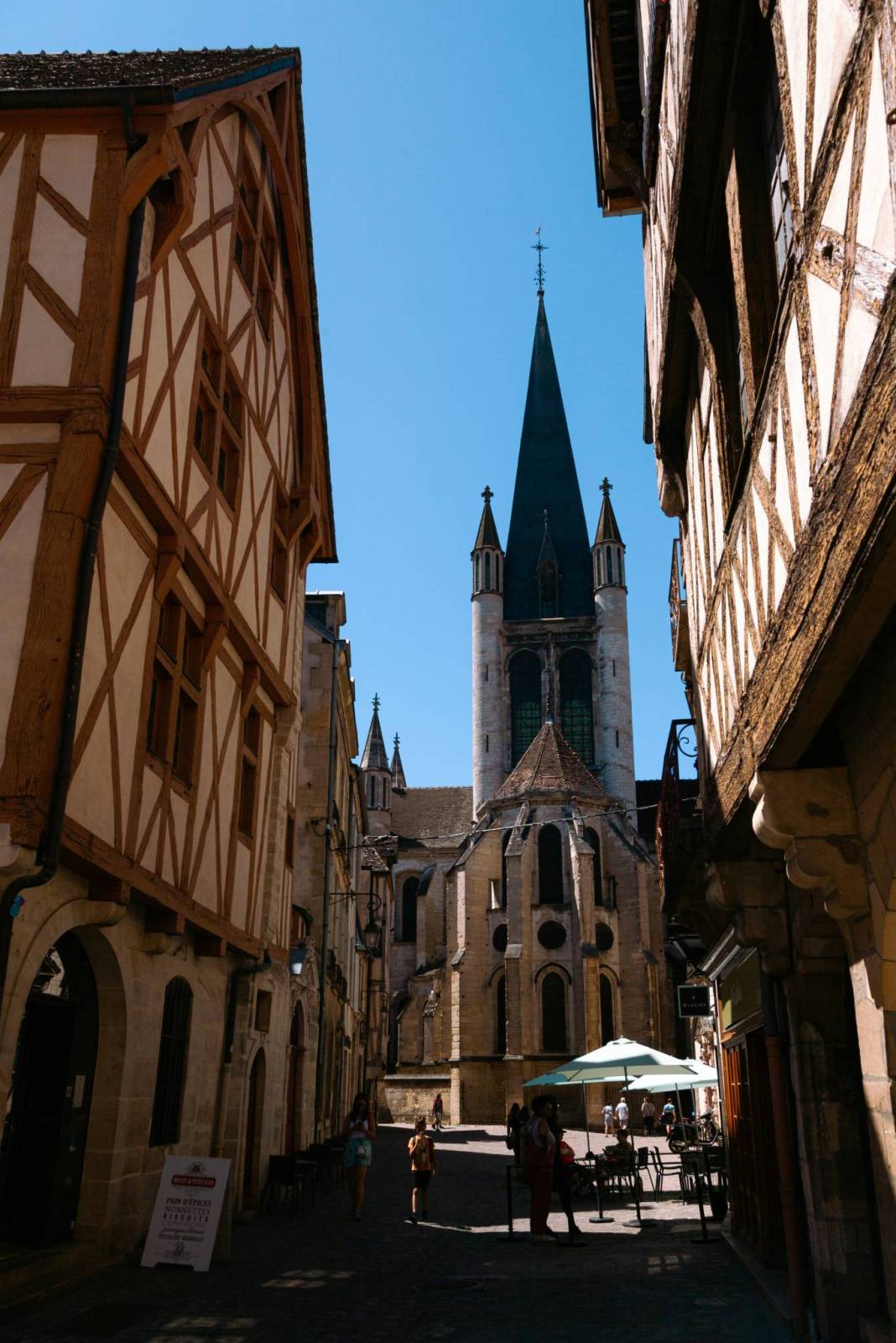
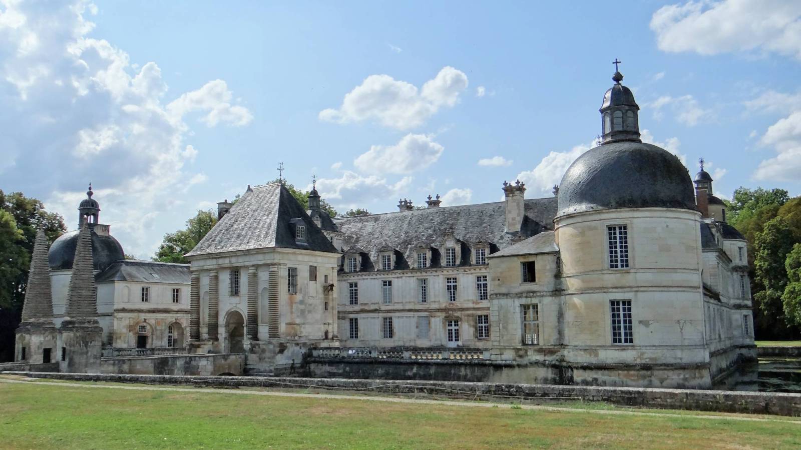
The route often starts in Dijon - the region's capital - known for its beautiful old town, the route of the Owl, the tower of Philippe the Good and the museum of fine arts. The route continues through the famous Côte de Nuits and Côte de Beaune wine regions, where you can visit villages such as Pommard, Meursault, Puligny-Montrachet and Santenay. There are renowned wineries, including Château de Pommard, Château de Meursault, Caveau de Puligny-Montrachet and the prestigious Domaine de la Romanée-Conti. Tastings often require advance reservations.

One of the more relaxing parts of the route are the sections along the canals - Canal du Centre and Canal Nivernais - leading through secluded villages, fields and wooded areas. On this leg, it's worth stopping in towns such as Paray-le-Monial, known for its impressive Romanesque basilica, and Clamecy, near which the lesser-known but very picturesque vineyards of Irancy stretch out.

The route also offers numerous historical and cultural attractions. Visit Renaissance castles such as Château de Tanlay and Château d'Ancy-le-Franc near the Burgundy Canal, the 12th century Cistercian abbey, a UNESCO World Heritage Site near Montbard- Abbaye de Fontenay. On the route we will also find the charming town of Bourbon-Lancy, with a well-preserved medieval center, also known for its thermal springs, the historic town of Auxerre with St. Stephen's Cathedral, a picturesque old town and numerous wineries, or Decize - a town located at the confluence of the Loire and the Nivernais Canal, with a historic center and a river port to which one must deviate from the route about 5 km in Champvert.

Level of difficulty of the route


The trail is generally easy and suitable for most cyclists. Most of the route runs on flat terrain along canals and green paths. Hilly sections occur mainly in the wine-growing areas, but the elevations are moderate - the total sum of ascents and descents along the entire trail is about 4,000-5,000 meters. The highest points reach up to 450-500 meters above sea level, while the lowest points - in river valleys and by canals - drop below 200 meters above sea level.

Route signage


The route is well prepared: it mainly follows marked voie verte bike paths and local roads with low traffic. Thanks to good rail transportation accessibility, individual sections can be easily shortened or modified.

Facilities for cyclists


Along the route, there are a number of “Accueil Vélo” facilities offering bicycle-friendly services, such as secure bicycle storage and special menus. Bike rental shops offering various models, including electric bikes, are available in many towns along the route. Some also offer luggage and bicycle transportation services . A wide range of accommodation is also available, from rustic guesthouses to elegant hotels, and numerous towns offer places to take a break, eat and shop for local products.

Mapa szlaku Tour of Burgundy


Zaznaczony na powyższej mapie szlak rowerowy Tour de Bourgogne à vélo to malownicza trasa o długości około 656 km, tworząca pętlę przez serce Burgundii. Prowadzi przez historyczne miasta, zamki, winnice o światowej renomie oraz spokojne kanały, co czyni ją idealnym wyborem dla miłośników wina, historii oraz aktywnego wypoczynku.

Atrakcje na trasie


Szlak często rozpoczynany jest w Dijon – stolicy regionu – znanej z pięknego starego miasta, trasy Sowy, wieży Filipa Dobrego i muzeum sztuk pięknych. Dalej trasa przebiega przez słynne regiony winiarskie Côte de Nuits i Côte de Beaune, gdzie można odwiedzić miejscowości takie jak Pommard, Meursault, Puligny-Montrachet czy Santenay. Znajdują się tam renomowane winiarnie, w tym Château de Pommard, Château de Meursault, Caveau de Puligny-Montrachet oraz prestiżowy Domaine de la Romanée-Conti. Degustacje często wymagają wcześniejszej rezerwacji.

Jednym z bardziej relaksujących fragmentów trasy są odcinki wzdłuż kanałów – Canal du Centre oraz Kanał Nivernais – prowadzące przez zaciszne wsie, pola i zalesione tereny. Na tym etapie warto zatrzymać się w miasteczkach takich jak Paray-le-Monial, znanym z imponującej bazyliki romańskiej, oraz Clamecy, w pobliżu którego rozciągają się mniej znane, ale bardzo malownicze winnice Irancy.

Szlak oferuje również liczne atrakcje historyczne i kulturowe. Warto odwiedzić renesansowe zamki, takie jak Château de Tanlay oraz Château d'Ancy-le-Franc w pobliżu kanału Burgundzkiego, opactwo cysterskie z XII wieku, wpisane na listę światowego dziedzictwa UNESCO, położone niedaleko Montbard- Abbaye de Fontenay. Na trasie znajdziemy również urokliwe miasteczko Bourbon-Lancy, z dobrze zachowanym średniowiecznym centrum, znane również z termalnych źródeł, historyczne miasto Auxerre z katedrą św. Szczepana, malowniczym starym miastem i licznymi winiarniami czy też Decize- miasto położone u zbiegu Loary i Kanału Nivernais, z historycznym centrum i portem rzecznymdo którego należy zboczyć z trasy około 5 km w miejscowości Champvert.

Poziom trudności trasy


Szlak jest generalnie łatwy i odpowiedni dla większości rowerzystów. Większość trasy prowadzi po płaskim terenie wzdłuż kanałów i zielonych ścieżek. Pagórkowate fragmenty występują głównie w terenach winiarskich, jednak przewyższenia są umiarkowane – całkowita suma podjazdów i zjazdów na całym szlaku to około 4000–5000 metrów. Najwyższe punkty osiągają do 450–500 m n.p.m., a najniższe – w dolinach rzecznych i przy kanałach – spadają poniżej 200 m n.p.m.

Oznakowanie trasy


Trasa jest dobrze przygotowana: prowadzi głównie po oznakowanych ścieżkach rowerowych typu „voie verte” i drogach lokalnych o małym natężeniu ruchu. Dzięki dobrej dostępności transportu kolejowego, poszczególne odcinki można łatwo skracać lub modyfikować.

Udogodnienia dla rowerzystów


Wzdłuż trasy znajduje się wiele obiektów "Accueil Vélo", oferujących usługi przyjazne rowerzystom, takie jak bezpieczne przechowywanie rowerów czy specjalne menu. W wielu miejscowościach wzdłuż trasy dostępne są wypożyczalnie rowerów oferujące różne modele, w tym rowery elektryczne. Niektóre z nich oferują również usługi przewozu bagażu i rowerów . Dostępna jest także bogata baza noclegowa – od rustykalnych pensjonatów po eleganckie hotele – a liczne miasteczka oferują miejsca na przerwę, posiłek i zakupy lokalnych produktów.

Comments