Ostróda (0.0 km) · Lichtajny (8.8 km) · Brzydowo (12.4 km) · Ornowo (16.5 km) · Lesiak Ostródzki (18.9 km) · Kajkowo (21.1 km) · Ostróda (23.4 km)
The trail is very attractive both in terms of scenery and history. The area around Ostróda features moraine hills dotted with farmland, offering views stretching to the distant horizon. For history buffs, there’s the manor house in Lichtajny, the church in Ornowo with its unique architecture, and, at the very end—easily accessible from the trail and situated in a very picturesque location—the Prussian hillfort in Lesiak Ostródzki. While on this bike tour, it’s also worth visiting Ostróda, especially the downtown area with its promenade along Lake Drwęckie.
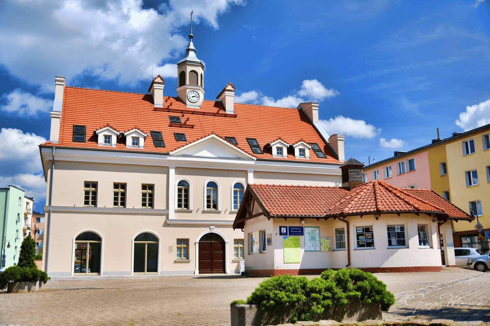
The trail begins next to the Tourist Information Center in Ostróda, on Tysiąclecia Państwa Polskiego Square. To start, head east toward the Church of St. Dominic Savio, then continue to Drwęcka Street and turn right. On the left, we pass the modern Greek Catholic Church of the Presentation of the Blessed Virgin Mary. A little further on, on a small hill, stands a historic water tower, built in the late 19th century. We turn left onto Grunwaldzka Street and continue straight ahead to the Expo Mazury exhibition grounds with the Ostróda Arena, passing the Grolman Barracks—popularly known as the Red Barracks—along the way. They were built between 1890 and 1898 and were listed as a historic monument a few years ago. From 2013 to 2019, the Ostróda Reggae Festival was held here. At this point, you can turn off the route toward the beach on Lake Sajmino. To reach it, turn right onto Bolesława Chrobrego Street. Nearby is a World War I cemetery. German soldiers who fell in 1914 during the Battle of Tannenberg are buried here.
We return to Grunwaldzka Street and arrive at the Expo Mazury complex. It is the second-largest trade fair and conference center in Poland. Its area is comparable to that of the Copernicus Science Center. The modern exhibition halls are located along the S7 expressway leading from Gdańsk to Warsaw. This is where the bike path ends. We continue straight ahead on the main road. This section is short, but let’s be careful! After passing the town sign for Górka, we turn right toward Lipowiec, following the sign. We ride along the shore of Lake Sement Mały on a road with a new asphalt surface. At the fork in the road, take a sharp right. From here, a beautiful view of the surrounding hills and a mosaic of fields unfolds. Turn left and continue along the old railroad embankment, which runs through densely wooded terrain. The surface is rough in places. After riding for nearly 2 km, we reach an asphalt road and turn left toward Lichtajny.
Lichtajny is a village founded in the 14th century. Here stands the restored neoclassical manor house of the von Rose family from the late 19th century. If we were to turn left at the manor park, we would reach a large, public beach with a pier on Lake Lichtajny, near which there is a Prussian hillfort. The park itself is fenced off and inaccessible. Continuing on, we see a chapel from 1909 by the roadside, featuring a nice bas-relief above the entrance. Leaving Lichtajn, we pass the remains of railway viaducts. Following the trail markers, we turn right, reach an intersection by a small chapel, and turn right again here. We reach Brzydowo via a tree-lined avenue. On the right, we pass a neo-Gothic school building. Following the signpost, we turn right toward Ornowo, and then pass under National Road No. 16. In the center of Ornowo, at the fork in the road marked by a cross, we turn right. While in the village, it’s worth visiting the Church of the Immaculate Conception of the Blessed Virgin Mary. This Gothic stone church dates back to the 15th century, and its Baroque main altar dates from 1690. The wooden tower, featuring a clock that still works today, was added in the 19th century. The church is surrounded by an old cemetery with 19th-century tombstones. From Ornowo, head north on a gravel road, following the trail markers. We turn right and cross the viaduct over National Road No. 16. This is part of the southern Ostróda bypass, which runs over the Morlińska Struga valley. The structure connecting the valley’s edges is impressive—it is 677 m long, and the span of its main arches is 206 m. These dimensions place this viaduct among the very best in Europe. Not far from the trail, about 150 m south of the fish ponds, lies the defensive settlement of the Prussian Sasins in Lesiak Ostródzki. They inhabited this place in the 10th and 11th centuries. At that time, it was a peninsula surrounded by water on three sides. Continuing northward, we pass under the national highway and arrive in Kajkowo, on Bukowa Street. To the left rises the highest point in the area, known as Napoleon’s Mountain. The village’s pre-war name was Buchwalde. Its current name was given in 1946 to honor the Masurian poet Michał Kajka (b. 1858, d. 1940), who, however, had little connection to this place; during his lifetime, he was associated with the Ełk area (you can visit a museum dedicated to him at his home in Ogródek). The final stretch of the route leads back to Ostróda. The trail runs not far from the beach on Lake Sajmino and the World War I cemetery, which we passed at the beginning of our trip. We enter the town via Szkolna Street. Along the way, on Henrykowska Street, we’ll also see a Masurian cottage, which, unfortunately, is in very poor condition. The trail is marked in yellow. Due to the very good surface, it is considered easy. Most of the route runs along paved roads; only short sections have a dirt surface. However, there are some fairly steep hills along the way, so it’s best to take a touring or hybrid bike on this trip. The most convenient place to take a break is the beach on Lake Lichtajny. You can also relax on the beach at Lake Sajmino.
Ostróda is easily accessible by train. The city lies on the route leading from Olsztyn to, among other places, Gdynia, Toruń, Bydgoszcz, Poznań, and Wrocław. Many regional and long-distance trains stop here. National Roads 15 and 16, as well as the S7 route from Warsaw to Gdańsk, run through the city. Those arriving by car can park in the large parking lot on Tysiąclecia Państwa Polskiego Square.
Ostróda
This city, situated on Lake Drwęckie, currently has a population of over 30,000. Its history dates back to the Middle Ages. In the 13th century, on the site of a Prussian settlement at the mouth of the Drwęca River, the Teutonic Knights built a wooden stronghold, which was replaced a century later by a stone castle. The Teutonic commander resided there. The location of the castle and the town was not chosen at random; they were built on a former island surrounded by branches of the river. It was not until the 19th century that the two outlets of the Drwęca River into the lake were filled in, leaving only one. For centuries, Ostróda remained a town of primarily local significance, although in 1807 Emperor Napoleon Bonaparte resided in the local castle, where he spent over two months “and from here ruled the empire,” as the inscription on a commemorative plaque on the castle wall states. The emperor’s stay was immortalized by the French painter Marie Nicolas Ponce-Camus in the painting “Napoleon Granting Favors to the Residents of Ostróda. March 1807.” The painting is located in Versailles, but a copy can be viewed at the museum housed in the castle. The French occupation was not a happy time for the town. Soldiers oppressed its residents, who appealed to the emperor regarding this matter. Ostróda’s development accelerated in the second half of the 19th century. In 1852, the first section of the Elbląg Canal was opened, and in 1872, a railroad line was extended to the city. Toward the end of World War II, Ostróda was occupied by the Red Army and more than 60% of the city was destroyed.
After World War II, new enterprises were established in the city, including the Railway Rolling Stock Repair Works and a meat processing plant (now known as “Morliny”). Today, Ostróda’s economic development is greatly influenced by its location along the expressway from Warsaw to Gdańsk. The castle, which had fallen into ruin, began to be rebuilt in the 1970s, and the work took 20 years. The structure is therefore a modern reconstruction. Originally, it was one story taller and had four wings. Today, it houses a museum. The fortress has become a stop on the Gothic Castles Trail. One of Ostróda’s oldest monuments is the Church of St. Dominic Savio, originally a 14th-century Gothic church. Unfortunately, it was destroyed by the Red Army in 1945. Rebuilt in the 1980s, it no longer exhibits a uniform architectural style due to numerous renovations. Thick Gothic walls can be seen at the base. Behind the church, a section of medieval defensive walls from the 15th century has survived to this day. The best vantage point for viewing the town and Lake Drwęckie is the tower of the Evangelical church. This imposing church was erected on a high escarpment that dominates the landscape between 1907 and 1909. The building resembles the massive, less ornate churches of the early Gothic period. The tower is crowned with a double cupola, a design that references the architecture of the Teutonic Order. From the top of the tower, visitors can admire a panoramic view of the surrounding area, and inside, they can see the clock mechanism—which is still in operation today—as well as three bells, one of which regularly strikes the hours.
Nearby stands the Church of the Immaculate Conception of the Blessed Virgin Mary, dating from the mid-19th century, built as the first Catholic church after the Reformation. Among its most valuable artifacts is a historic 14th-century wooden Pietà. The medieval street layout has been preserved in the city center. Most of the buildings, however, date from the turn of the 19th and 20th centuries. The town hall—like much of the old town—was burned down at the end of World War II. It was rebuilt in 2018, modeled after the 18th-century structure. In front of City Hall stands the original fountain from 1907. It was originally a monument to three German emperors. Their portraits, in the form of medallions, were removed in 1945. In 2004, in connection with Poland’s accession to the EU, it was renamed the Monument to European Unity. The world-renowned writer Hans Hellmut Kirst was born in 1914 at 10 Sienkiewicza Street. A plaque dedicated to him commemorates this fact.
Ostróda also offers many recreational attractions. Among the popular places for walking is the European Boulevard—a promenade with a pier on Lake Drwęckie. This is undoubtedly the most attractive part of the city for tourists. In previous years, a water-ski lift operated here during the summer season. Near the city beach stands an interesting historical monument: the Bismarck Tower from 1902. It is the oldest tower in Masuria commemorating the German chancellor. Nearby is also the city stadium, which boasts excellent infrastructure. It was prepared to host one of the national soccer teams during the 2012 European Championship. Unfortunately, it was not selected by any team.
The Elbląg Canal, which begins in Ostróda, is a world-class hydraulic engineering monument and, at the same time, a popular waterway 183 km long (including branches), which can be navigated by yacht, kayak, or—in part—by sightseeing boat. Boat cruises from the marina on Lake Drwęckie are one of the area’s biggest tourist attractions. In the city center is the Ostróda Lock—one of the historic hydraulic structures worth seeing, although the Elbląg Canal is best known for its unique boat ramps. Ostróda regularly hosts music festivals. The most popular of these is the Ostróda Reggae Festival, which dates back to 1983. Concerts are held, among other venues, at the amphitheater on Lake Drwęckie, which can accommodate 2,500 spectators.