


Charakterystyka trasy

Komentarze
NA TYCH TRASACH PRZYDA CI SIĘ MAPOPRZEWODNIK LUB MAPA Z NASZEJ APLIKACJI
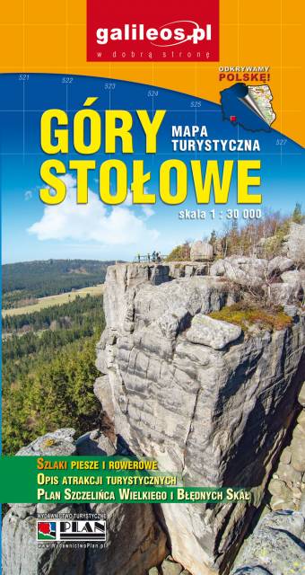
Mapa turystyczna Gór Stołowych w skali 1:30 000, zaktualizowana w terenie. Na mapie oznaczono czasy przejść. Znajdziemy tu szlaki turystyczne, rowerowe i piesze oraz najważniejsze informacje o charakterze turystycznym, a także informacje praktyczne. Rok wydania 2021
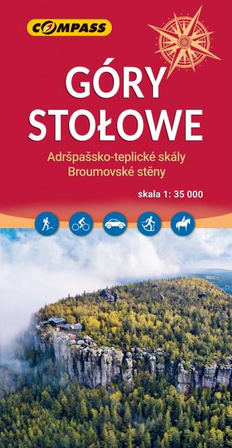
Mapa turystyczna Gór Stołowych przedstawia niezwykle malowniczy zakątek SUdetów. Góry Stołowe położone są w Sudetach Środkowych, na styku z Sudetami Wschodnimi. Mapa przedstawia obszar zamknięty na zachodzie przez czeski Hronov, na południu Duszniki-Zdrój, na wschodzie Szalejów Górny oraz na północy Police. Na mapie również czeskie Góry Stołowe: Adršpašsko-teplické skály i Broumovské stěny. Rok wydania 2023
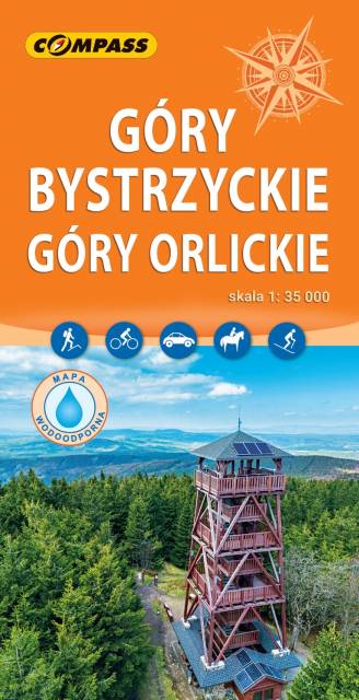
Mapa wydawnictwa Compass Góry Bystrzyckie i Góry Orlickie w skali 1:35 000. Jest to mapa na której znalazły się tereny od Międzylesia przez Bystrzycę Kłodzką, Kudowę-Zdrój po Náchod. Oprócz znanych uzdrowisk (Kudowa-Zdrój, Duszniki-Zdrój, Polanica-Zdrój, Długopole-Zdrój) znajdziemy tu zamek w Międzylesiu, słynny wiadukt w Lewinie Kłodzkim czy ogród japoński w Jarkowie. Rok wydania 2024
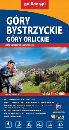
Mapa Gór Bystrzyckich to nowe, uaktualnione wydanie. Mapa obejmuje obszar Gór Bystrzyckich i Orlickich, z uzdrowiskami Polanica Zdrój i Duszniki Zdrój oraz ośrodkami narciarskimi w Zieleńcu i Deštnem. Jest to obszar ograniczony współrzędnymi 16°18’ - 16°40’ długości geograficznej wschodniej oraz 50°06’-50°26’ szerokości geograficznej północnej. Znajdują się tu takie atrakcje jak Torfowisko pod Zieleńcem i przełom Dzikiej Orlicy Zemská brána. Na mapie zaznaczono informacje przydatne turyście, jak zabytki, noclegi, granice obszarów chronionych, szczególnie atrakcyjne miejsca zaznaczono żółtą ramką. W miejscowościach opisano nazwy ulic. Podano aktualne przebiegi szlaków pieszych, rowerowych, narciarskich i konnych, łącznie z kilometrażem co pozwoli łatwiej zaplanować wycieczkę. Przy szlakach pieszych podano także orientacyjny czas przejścia. Zaznaczono wyciągi narciarskie i trasy zjazdowe. Ukształtowanie terenu pokazano przy pomocy warstwic o cięciu co 20 m.
Położone na granicy polsko-czeskiej Góry Orlickie to najwyższy masyw Sudetów Środkowych (najwyższy szczyt – Wielka Desztna (Velká Deštná), 1115 m n.p.m.). Większość masywu znajduje się w Czechach. Po polskiej stronie główne centra turystyczne to Duszniki-Zdrój (baza wypadowa w przyległe pasma) oraz wieś Zieleniec - znany ośrodek narciarski. Mapa obejmuje także polską część Gór Stołowych, pasma górskiego znanego z wyjątkowych formacji skalnych.
Rok aktualizacji: 2016/2017
Ziemi Kłodzkiej - historycznej krainy (teren dawnego hrabstwa kłodzkiego) obejmującej Kotlinę Kłodzką i otaczające ją tereny górskie: Góry Stołowe, Góry Sowie, Góry Bardzkie, Góry Złote, Góry Bialskie, Masyw Śnieżnika, Góry Bystrzyckie, Góry Orlickie. Zasięg mapy wyznaczają od wschodu Złoty Stok i Javornik po czeskiej stronie, od zachodu Kudowa-Zdrój, Nachod, Police, Teplice (zatem praktycznie całe Góry Stołowe) po czeskiej stronie. Od północy zasięg wyznaczają: Ząbkowice Śląskie i Srebrna Góra, od południa obrzeża miasta Zamberk po czeskiej stronie. Rok wydania: 2024