category-icon

Karlovy Vary - Ostrov wieża Śmierci - Jachymov sztolnia Astoria

29 km
525 m
337 m
Jachymov, Ostrov
Zdjęcie 1
Zdjęcie 2
Zdjęcie 3
Zdjęcie 4
Zdjęcie 5
Zdjęcie 6

Route characteristics

2022-06-14
Jachymov, Ostrov
category-icon
29 km
525 m
337 m
5.0/6
W drodze powrotnej z Karlovych Var , wstąpiłem do Jachymova z nadzieją ,że uda mi się zwiedzić sztolnie związane z wydobyciem uranu . Po drodze wstąpiłem jeszcze do Ostrova , gdzie znajduje się tzw wieża śmierci , gdzie mielono rudę uranową . Obiekt dostępny do zwiedzania tylko w soboty i w niedzielę . W Jachymovie sztolnię C1 pomimo ,że miała być czynna , nie udało mi się zwiedzić .

Comments

You may find the map from our app useful on this route

Doupov Mountains
TOURIST MAP IN THE TRASEO APP
Doupov Mountains
Doupov Mountains (Czech: Doupovské hory, German: Duppauer Gebirge) is a cenozoic volcanic mountain range with the typical structure of stratovolcano. The centre of the stratovolcano was in the place of a former town of Doupov. The highest mountain is Hradiště (934 metres), the lowest point is by the river Ohře near Kadaň (cca 275 metres). In 1945, most of the German population was forced out so that Doupov Mountains were almost completely unpopulated. It became the Army Training Area in 1953 and still serves this purpose for NATO forces. Some scenes in the 1967 post-apocalyptic film, The End of August at the Hotel Ozone, were filmed in Doupov.
Bohemian Spa. Kaiserwald
TOURIST MAP IN THE TRASEO APP
Bohemian Spa. Kaiserwald
The Kaiserwald, also called the Emperor's Forest, is a mountain range in the western Czech Republic in the triangle formed by famous Czech spa resorts: Karlovy Vary (Carlsbad), Mariánské Lázně (Marienbad) and Františkovy Lázně (Franzensbad).
Ore Mountains Range. Western Part
TOURIST MAP IN THE TRASEO APP
Ore Mountains Range. Western Part
The map presents western part of The Ore Mountains or Ore Mountains Range (Czech: Krušné hory) in Central Europe, which have formed a natural border between Saxony and Bohemia for around 800 years, from the 12th to the 20th centuries. Today, the border between Germany and the Czech Republic runs just north of the main crest of the mountain range. The highest peaks are the Klínovec (German: Keilberg), which rises to 1,244 metres above sea level and the Fichtelberg (1,215 metres). The culture of the Ore Mountains was shaped mainly by mining that goes back to the Middle Ages.
Czechy i Słowacja – mapa samochodowa
TOURIST MAP IN THE TRASEO APP
Czechy i Słowacja – mapa samochodowa

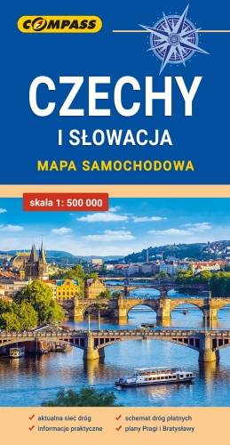
Mapa samochodowa Słowacji i Czech zawiera: aktualną sieć autostrad, dróg ekspresowych i głównych, z podziałem na dwupasmowe i jednopasmowe; drogi w budowie, numerację dróg oraz kilometraż. Na mapie zaznaczono: przejścia graniczne, Autostradowe Miejsca Obsługi Podróżnych, wybrane stacje benzynowe, parkingi i promy wodne, porty lotnicze, obszary leśne, parki narodowe, uzdrowiska, większe ośrodki narciarskie, obiekty na Liście UNESCO. Legenda w językach: polskim, angielskim, czeskim i słowackim.
Mapa dodatkowo zawiera:
- schemat dróg płatnych na Słowacji i w Czechach;
- wykaz węzłów na autostradach i drogach ekspresowych na Słowacji;
- plany Pragi i Bratysławy;
- schemat metra w Pradze;
- informacje praktyczne dla podróżujących samochodem po Słowacji i Czechach (m.in.: wybrane przepisy drogowe, wymagane dokumenty, obowiązkowe wyposażenie samochodu, rodzaje winiet).
Mapę offline można zakupić w aplikacji Traseo na urządzenia mobilne. Rok wydania 2020