


Charakterystyka trasy

Komentarze
NA TYCH TRASACH PRZYDA CI SIĘ MAPOPRZEWODNIK LUB MAPA Z NASZEJ APLIKACJI
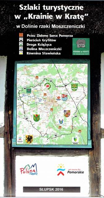
Najnowsza mapa regionu, której głównym elementem jest Pierścień Gryfitów. Mapa jest dostowana zarówno do wędrówek pieszych, jak i rowerowych oraz samochodowych wycieczek. Sam Pierścień Gryfitów, to długa trasa rowerowa, na której przemierzenie należy przeznaczyć co najmniej dwa dni. Dzięki mapie Krainy w Kratę można dobrze rozplanować podróż, uwzględniając okoliczne atrakcje. Przystępna skala 1:50 000 pozwala łatwo nawigować w ternie i zawsze odnaleźć właściwą drogę. Na mapie znajdziemy także Słupsk, który zwany jest Paryżem Północy, który swoim wyglądem przypomina zielony ogród pełen kwiatów.
Mapa turystyczna "Wybrzeże Bałtyku. Ustka - Darłowo" prezentuje przede wszystkim liczne szlaki piesze i rowerowe, znaleźć na niej można także szlaki kajakowe. Dla łatwiejszej orientacji w terenie podano także nazwy ulic. Mapa Ustka - Darłowo obejmuje także obszary jeziora Wicko, jeziora Kopań oraz fragment Jeziora Bukowo.
Opracowanie kartograficzne obejmuje obszar Powiatu Bytowskiego. Na mapie zaznaczono informacje przydatne turyście, jak zabytki, noclegi, gastronomie, granice obszarów chronionych. Podano aktualne przebiegi szlaków pieszych, rowerowych i konnych, łącznie z kilometrażem, co pozwoli łatwiej zaplanować wycieczkę. Ukształtowanie terenu pokazano przy pomocy warstwic o cięciu co 10 m.
Rok wydania: 2018