category-icon

GDYNIA OKSYWIE - MRZEZINO - ŻELISTRZEWO - PUCK (trening do triathlon herbolife Gdynia 2015))

54 km
2 h 12 min
206 m
Gdynia

CHARAKTERYSTYKA TRASY

2015-04-11
Gdynia
category-icon
54 km
206 m
195 m
Łatwy
2 h 12 min
2.8/6
Szybka trasa na popołudniowy trening. Przejazd tylko do Kosakowa trochę męczący ze względu na ścieżki rowerowe i ruch jaki na nich jest. Trasę zaczynamy i kończymy w Gdyni na Oksywiu. Zawracamy na rondzie przy m. Puck. Meczący podjazd w Mrzezinie ale dobry górski trening za to z powrotem super prędkość. Należy uważać na wiatry w tym rejonie bo potrafi wiać....

Komentarze

NA TEJ TRASIE PRZYDA CI SIĘ MAPA Z NASZEJ APLIKACJI

Tricity Landscape Park
MAPA TURYSTYCZNA W APLIKACJI TRASEO
Tricity Landscape Park

Tricity Landscape Park is a protected area in northern Poland, in the Pomeranian Voivodeship, close to Gdynia and Gdańsk. Cycling, walking and horse trails are marked on the map, as well as other information useful for tourists.

Mierzeja Helska
MAPA TURYSTYCZNA W APLIKACJI TRASEO
Mierzeja Helska

Tourist map of Mierzeja Helska and surroundings with current hiking and cycling routes. The map includes: Jastarnia, Władysławowo, Kuźnica, Hel, Jurata, Jastrzębia Góra, Karwia, Chałupy, Jurata and Puck area. Year of publication 2016

Kashubian Baltic Coast
MAPA TURYSTYCZNA W APLIKACJI TRASEO
Kashubian Baltic Coast

Kashubian Lake District is a region in nothern Poland, largely populated by Kashubians, from which the name of the region originates. In this characteristic post-glacial landscape with hills rising up to 656 feet above sea level, there are almost 250 lakes. At the same time, it is also one of the largest forest areas in Poland. All the hiking and walking routes, tourist attractions, fortifications and lighthouses are marked on the map.

Central Kashubia
MAPA TURYSTYCZNA W APLIKACJI TRASEO
Central Kashubia

Kashubia is an area in eastern Pomerania, a region of north-western Poland. In this characteristic post-glacial landscape with hills rising up to 656 feet above sea level, there are almost 250 lakes. At the same time, it is also one of the largest forest areas in Poland. Located west of Gdańsk and the mouth of the Vistula river, it is inhabited by members of the Kashubian ethnic group. The map depicts the middle part of the region, the Tuchola Forest and part of the Tricity Landscape Park near Gdańsk.

Pomorskie. Zamki i pałace
MAPA TURYSTYCZNA W APLIKACJI TRASEO
Pomorskie. Zamki i pałace

Mapa województwa pomorskiego na której zaznaczono za pomocą ilustracji zamki, dwory i pałace w województwie pomorskim. Mapa zawiera aktualną sieć dróg. Łącznie uwzględniono 121 miejsc wartych odwiedzenia.

Województwo Pomorskie
MAPA TURYSTYCZNA W APLIKACJI TRASEO
Województwo Pomorskie

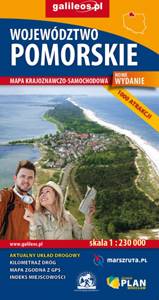
Mapa całego województwa pomorskiego z aktualnym przebiegiem dróg. Opisano ich numerację i kilometraż, zaznaczono również stacje paliw. Miejsca ciekawe, warte odwiedzenia podkreślono kolorem żółtym. Mapa posiada opisaną siatkę geograficzną WGS 84 przez co można ją zastosować do urządzeń z GPSem. Na rewersie umieszczono indeks miejscowości (miasta, wsie, przysiółki, duże dzielnice) oraz mapki tematyczne z podziałem administracyjnym, kodami pocztowymi, ochroną przyrody i krainami goegraficznymi. 

Miejscowości na trasie